Vẽ một đường GeoJSON
Vẽ một polyline bằng cách phân tích một file GeoJSON với Vietbando iOS SDK.
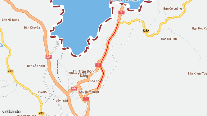
Tải xuống example.geojson và thêm nó vào dự án.
#import "ViewController.h"
@import Vietbando;

@interface ViewController () <VBDMapViewDelegate>

@property (nonatomic) VBDMapView *mapView;

@end

@implementation ViewController

- (void)viewDidLoad {
    [super viewDidLoad];

    self.mapView = [[VBDMapView alloc] initWithFrame:self.view.bounds];
    self.mapView.autoresizingMask = UIViewAutoresizingFlexibleWidth | UIViewAutoresizingFlexibleHeight;

    // Set the map's center coordinate
    [self.mapView setCenterCoordinate:CLLocationCoordinate2DMake(21.959879197280166, 106.705890858815)
                            zoomLevel:13
                             animated:NO];

    [self.view addSubview:self.mapView];

    // Set the delegate property of our map view to self after instantiating it.
    self.mapView.delegate = self;

    [self drawPolyline];
}

- (void)drawPolyline
{
    // Perform GeoJSON parsing on a background thread
    dispatch_queue_t backgroundQueue = dispatch_get_global_queue(DISPATCH_QUEUE_PRIORITY_DEFAULT, 0);
    dispatch_async(backgroundQueue, ^(void)
    {
        // Get the path for example.geojson in the app's bundle
        NSString *jsonPath = [[NSBundle mainBundle] pathForResource:@"example" ofType:@"geojson"];

        // Load and serialize the GeoJSON into a dictionary filled with properly-typed objects
        NSDictionary *jsonDict = [NSJSONSerialization JSONObjectWithData:[[NSData alloc] initWithContentsOfFile:jsonPath] options:0 error:nil];

        // Load the `features` dictionary for iteration
        for (NSDictionary *feature in jsonDict[@"features"])
        {
            // Our GeoJSON only has one feature: a line string
            if ([feature[@"geometry"][@"type"] isEqualToString:@"LineString"])
            {
                // Get the raw array of coordinates for our line
                NSArray *rawCoordinates = feature[@"geometry"][@"coordinates"];
                NSUInteger coordinatesCount = rawCoordinates.count;

                // Create a coordinates array, sized to fit all of the coordinates in the line.
                // This array will hold the properly formatted coordinates for our VBDPolyline.
                CLLocationCoordinate2D coordinates[coordinatesCount];

                // Iterate over `rawCoordinates` once for each coordinate on the line
                for (NSUInteger index = 0; index < coordinatesCount; index++)
                {
                    // Get the individual coordinate for this index
                    NSArray *point = [rawCoordinates objectAtIndex:index];

                    // GeoJSON is "longitude, latitude" order, but we need the opposite
                    CLLocationDegrees lat = [[point objectAtIndex:1] doubleValue];
                    CLLocationDegrees lng = [[point objectAtIndex:0] doubleValue];
                    CLLocationCoordinate2D coordinate = CLLocationCoordinate2DMake(lat, lng);

                    // Add this formatted coordinate to the final coordinates array at the same index
                    coordinates[index] = coordinate;
                }

                // Create our polyline with the formatted coordinates array
                VBDPolyline *polyline = [VBDPolyline polylineWithCoordinates:coordinates count:coordinatesCount];

                // Optionally set the title of the polyline, which can be used for:
                //  - Callout view
                //  - Object identification
                // In this case, set it to the name included in the GeoJSON
                polyline.title = feature[@"properties"][@"name"]; // "Quốc lộ 29"

                // Add the polyline to the map, back on the main thread
                // Use weak reference to self to prevent retain cycle
                __weak typeof(self) weakSelf = self;
                dispatch_async(dispatch_get_main_queue(), ^(void)
                {
                    [weakSelf.mapView addAnnotation:polyline];
                });
            }
        }

    });
}

- (CGFloat)mapView:(VBDMapView *)mapView alphaForShapeAnnotation:(VBDShape *)annotation
{
    // Set the alpha for all shape annotations to 1 (full opacity)
    return 1.0f;
}

- (CGFloat)mapView:(VBDMapView *)mapView lineWidthForPolylineAnnotation:(VBDPolyline *)annotation
{
    // Set the line width for polyline annotations
    return 2.0f;
}

- (UIColor *)mapView:(VBDMapView *)mapView strokeColorForShapeAnnotation:(VBDShape *)annotation
{
    // Set the stroke color for shape annotations
    // ... but give our polyline a unique color by checking for its `title` property
    if ([annotation.title isEqualToString:@"Quốc lộ 29"])
    {
        return [UIColor colorWithRed:1.0 green:0.0 blue:0.0 alpha:1.0];
    }
    else
    {
        return [UIColor redColor];
    }
}

@end