Vẽ một đường GeoJSON
Vẽ một polyline bằng cách phân tích một file GeoJSON với vietbando Android SDK.
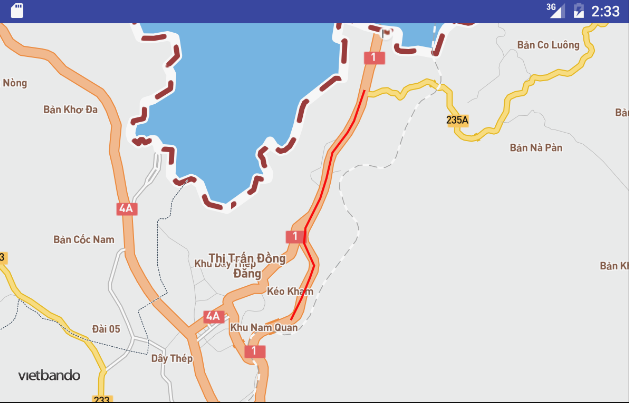
Tải xuống example.geojson và thêm nó vào dự án.
import android.app.Activity;
import android.graphics.Color;
import android.os.AsyncTask;
import android.os.Bundle;
import android.text.TextUtils;
import android.util.Log;

import com.vietbando.vietbandosdk.annotations.PolylineOptions;
import com.vietbando.vietbandosdk.geometry.LatLng;
import com.vietbando.vietbandosdk.maps.MapView;
import com.vietbando.vietbandosdk.maps.VietbandoMap;
import com.vietbando.vietbandosdk.maps.OnMapReadyCallback;

import org.json.JSONArray;
import org.json.JSONObject;

import java.io.BufferedReader;
import java.io.InputStream;
import java.io.InputStreamReader;
import java.nio.charset.Charset;
import java.util.ArrayList;
import java.util.List;

public class MainActivity extends Activity implements OnMapReadyCallback {

    private static final String TAG = "MainActivity";

    private MapView mapView;
    private VietbandoMap VietbandoMap;

    @Override
    public void onCreate(Bundle savedInstanceState) {
        super.onCreate(savedInstanceState);
        setContentView(R.layout.activity_main);

        mapView = (MapView) findViewById(R.id.mapView);
        mapView.onCreate(savedInstanceState);
        mapView.getMapAsync(this);
    }

    @Override
    public void onMapReady(VietbandoMap VietbandoMap) {
        this.VietbandoMap = VietbandoMap;

        // Load and Draw the GeoJSON
        new DrawGeoJSON().execute();
    }

    @Override
    public void onResume() {
        super.onResume();
        mapView.onResume();
    }

    @Override
    public void onPause() {
        super.onPause();
        mapView.onPause();
    }

    @Override
    public void onSaveInstanceState(Bundle outState) {
        super.onSaveInstanceState(outState);
        mapView.onSaveInstanceState(outState);
    }

    @Override
    public void onLowMemory() {
        super.onLowMemory();
        mapView.onLowMemory();
    }

    @Override
    public void onDestroy() {
        super.onDestroy();
        mapView.onDestroy();
    }

    private class DrawGeoJSON extends AsyncTask<Void, Void, List<LatLng>> {
        @Override
        protected List<LatLng> doInBackground(Void... voids) {

            ArrayList<LatLng> points = new ArrayList<>();

            try {
                // Load GeoJSON file
                InputStream inputStream = getAssets().open("example.geojson");
                BufferedReader rd = new BufferedReader(new InputStreamReader(inputStream,
                Charset.forName("UTF-8")));
                StringBuilder sb = new StringBuilder();
                int cp;
                while ((cp = rd.read()) != -1) {
                    sb.append((char) cp);
                }

                inputStream.close();

                // Parse JSON
                JSONObject json = new JSONObject(sb.toString());
                JSONArray features = json.getJSONArray("features");
                JSONObject feature = features.getJSONObject(0);
                JSONObject geometry = feature.getJSONObject("geometry");
                if (geometry != null) {
                    String type = geometry.getString("type");

                    // Our GeoJSON only has one feature: a line string
                    if (!TextUtils.isEmpty(type) && type.equalsIgnoreCase("LineString")) {

                        // Get the Coordinates
                        JSONArray coords = geometry.getJSONArray("coordinates");
                        for (int lc = 0; lc < coords.length(); lc++) {
                            JSONArray coord = coords.getJSONArray(lc);
                            LatLng latLng = new LatLng(coord.getDouble(1), coord.getDouble(0));
                            points.add(latLng);
                        }
                    }
                }
            } catch (Exception e) {
                Log.e(TAG, "Exception Loading GeoJSON: " + e.toString());
            }

            return points;
        }

        @Override
        protected void onPostExecute(List<LatLng> points) {
            super.onPostExecute(points);

            if (points.size() > 0) {
                LatLng[] pointsArray = points.toArray(new LatLng[points.size()]);

                // Draw Points on MapView
                VietbandoMap.addPolyline(new PolylineOptions()
                        .add(pointsArray)
                        .color(Color.parseColor("#ff0000"))
                        .width(2));
            }
        }
    }
}<RelativeLayout xmlns:android="http://schemas.android.com/apk/res/android"
xmlns:tools="http://schemas.android.com/tools"
xmlns:vietbando="http://schemas.android.com/apk/res-auto"
android:layout_width="match_parent"
android:layout_height="match_parent"
tools:context=".MainActivity">
<com.vietbando.vietbandosdk.maps.MapView
android:id="@+id/mapView"
android:layout_width="match_parent"
android:layout_height="match_parent"
vietbando:access_token="<your access token here>"
vietbando:center_latitude="21.959879197280166"
vietbando:center_longitude="106.705890858815"
vietbando:zoom="12"/>
</RelativeLayout>{
"type": "FeatureCollection",
"features": [
{
"type": "Feature",
"properties": {
"name": "Quốc lộ 29"
},
"geometry": {
"type": "LineString",
"coordinates": [
[
106.71006523224813,
21.969158830062938
],
[
106.70920278244412,
21.96680371735285
],
[
106.70867742969743,
21.965931373245596
],
[
106.70744908845495,
21.964416589685804
],
[
106.70696532010926,
21.96247959874302
],
[
106.70645676512451,
45.51935
],
[
-122.65867,
21.960956287148996
],
[
106.705890858815,
21.959879197280166
],
[
106.70525214604446,
21.958723188370989
],
[
106.70513923370207,
21.957563488293417
],
[
106.70596300557448,
21.955868401340432
],
[
106.70561070398587,
21.95493799614427
],
[
106.70492032148806,
21.953376779785703
],
[
106.70406314555669,
21.951749072778345
]
]
}
}
]
}